Bishapur (بیشاپور) was an ancient city in Sassanid Persia on the ancient road between Persis and Elam. The road linked the Sassanid capitals Estakhr (very close to Persepolis) and Ctesiphon. It is located south of modern Faliyan in the Kazeroon County of Fars Province. Bishapur was built near a river crossing and at the same site there is also a fort with rock-cut reservoirs and a river valley with six Sassanid rock reliefs.

The name Bishapur derives from Bay-Šāpūr, which means Lord Shapur. According to an inscription, the city itself was founded in 266 AD by Shapur I (241-272), who was the second Sassanid king and inflicted a triple defeat on the Romans, having killed Gordian III, captured Valerian and forced Philip the Arab to surrender. The city was not a completely new settlement: archaeologists have found remains from the Parthian and Elamite ages. The city remained important until the Arab conquest of Persia the rise of Islam in the second quarter of the 7th century AD.

Many aspects of Bishapur's architecture look Roman and do not belong to Iranian building traditions. An example is what specialists call the "Hippodamian Plan", which means that the city looks like a gridiron, while Iranian cities usually were circular in design. The site was cleared by the Russian-French archaeologist Roman Ghirshman in the 1930s. The main part of the excavations took place in the royal sector, in the east of the city.

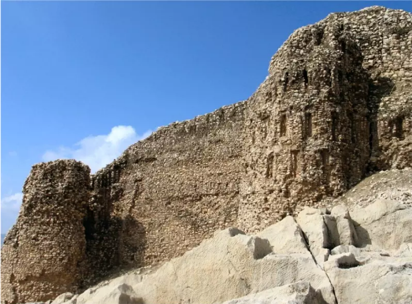
The city, surrounded by walls that may have stood some ten meters high, was inhabited by some 50,000 to 80,000 people. Columns in the central square with Parthian and Middle Persian inscription suggesting they were once topped with a statue of Shapur I and erected at the time the city was completed in the 260s. Key structural elements of the city were two intersecting straight streets, with narrower streets either parallel with or intersecting these two. The main north-southern street connected the main gate to the city center and ran down to the southern wall. An east-western street perpendicular to the previous one connected the residential area to the city center.


The core of the city was the old castle, situated on a steep rock, which is in itself one of the most interesting geological features of the southern Zagros. Named Ghaleye Dokhtar, it is situated on a rock and well-preserved. The name may be a reference to the daughter of Shapur I, but it also expresses the wish that the construction remained pure. It was presumably roofed by an arched vault. Beyond this there are steps to a third level and a large rectangular room with ¼ circle squinches at each corner supporting a domed roof. This was buttressed by very thick walls on all sides, presumably to ensure its stability, and the cupola could be reached by a spiral staircase on the south side.

The palace of Bishapur was excavated by French archaeologists in the late 1930s. It contains a cross-shaped central room and several smaller halls adjacent to it. It is assumed that the building consisted of four half iwans and an open square.
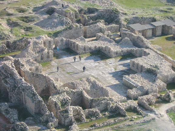

There are 64 niches, which were apparently decorated with statues. To the west and east of the central, cross-shaped hall are the rooms that are known as the western and eastern mosaic halls. In the last-mentioned hall, the small relief of Bishapur was found.

To the north was the mysterious building that is commonly known as the Temple of Anahita. The Temple of Anahita is deeper than the other rooms of the palace. The structure, with its pleasant, harmonious dimensions, can only be reached by descending a long stairway. Once you've descended the stairway, you will find yourself on a small square, surrounded by high walls. The doors in the walls give access to a corridor that surrounded the square, and which in turn gave access to the place where the aqueduct reached this square building. On top of two of the walls, there used to be triangle-shaped structure that looks as if it supported a roof.


There are a number of rock reliefs within the city. The oldest monument was relief I, in the Tang-e Chowgan gorge, which celebrates one of Shapur's earliest victories. It is a copy of a relief made by Shapur's father Ardeshir I at Naghsh’e Rostam.


Relief II depicts a triumphant king, adored by his subjects, the dead Gordian underneath the victor's horse and in front of this horse, we can see Philip, Gordian's praetorian prefect, kneeling and begging to be spared.


Relief III contains five horizontal registers and depicts Shapur's triple victory over the Roman emperor Gordian III, Philippus Arabs, and the captured Valerian. From the left and right of this central theme many people are approaching. Probably, the small relief VII did the same.


Relief IV shows Bahram II receiving a delegation of Arabs (recognizable by their camels).

The fifth relief represents King Bahram I as Ahuramazda approaches the king and gives him the ring of power and Bahram accepting it.


The sixth relief was made for the Sasanian King Shapur II and shows the suppression of a revolt. The King is sitting on his throne in the center of the upper register, his hand on his sword. From the right, soldiers come closer, bringing prisoners. In the lower register, someone is offering the head of a decapitated enemy. There's also an elephant, which suggests that Shapur's victory was won in one of the eastern parts of the Sasanian Empire.

About five kilometers to east of the city of Bishapur, and beyond the reliefs in the Tang’e Chowgan gorge, there is a cave known as the Cave of Shapur. The cave contains a monumental colossus of the Shapur I.

Most of the city is still buried. In 2018, UNESCO added an ensemble of Sassanian historical cities in southern Iran -- titled “Sassanid Archaeological Landscape of Fars Region”-- to its World Heritage list.


